This webpage contains information assembled over many years for my own
use, starting in 1974. It's grown into quite a big file. I am happy to
share it.
This information is non-commercial, non-profit, and comes with no
warranty of any kind.
This information is from a large variety of sources. I usually didn't
keep track of them. Some of this information is quite old... Some of
it is just for my personal use... Caveat emptor. But I always
appreciate updates, corrections, etc.
To make sense of this file you'll probably need a map. The park
brochure is a start, but the AAA map mentioned earlier is much
more complete for place names and road distances.
-
Anywhere:
Hike up any unnamed canyon and lose yourself for a day amidst the
eternal vast silence. Stop the car just about anywhere and walk 20
minutes perpendicular to the road in either direction just to see
what's there. (And pick up any trash you find...) For instance, the
winter-time reflecting ponds north of Furnace Creek are neat,
and I found them this way. Try to leave no footprints, it's a
challenge...
-
Scotty's Castle:
If it's your first visit and you're feeling touristy, tour the Castle
(50 minute tour, often a 1 hour wait, $11 in 0801), or the Harmony
Borax Ruins or Rhyolite or Stovepipe Well or
Skidoo, or even the museum at Furnace Creek Ranch...
-
(h)
Ubehebe Crater:
3000-year-old blast, 1/2 mi wide, scattered cinders over 6 sq mi.
Hike around it, ~1.5 mi and/or to the bottom and back (steep climb
out, ~600').
Also hike to other craters nearby, like Little Hebe, 1/2 mi OW
from parking; just 1000 years old?
-
(nh)
Red Wall Canyon:
From Titus Canyon mouth parking lot 3 mi off pavement, hike 3
mi OW; or, hike 2.2 mi from paved road to canyon mouth, up the
center of the alluvial fan, watching for red rocks. Dry fall,
rock climbing required, ~1 mi into canyon. But search for "Talus Jack
Bypass" for a workaround route that someone found.
Kevin Keirn wrote: "Awesome! Cool. Neat. Worth the effort. Big
red walls. Bigger. Lots of neat slots and a lot more waterfalls and
mini-waterfalls than Fall Canyon, although not as polished
slots as those in Fall about the falls. However, the walls
seemed to go up higher in Red Wall . Sometimes 6-10' wide and
150' (?) tall. You must be with at least one other person, and it
sure would've been nice to have a rope. Rock experience required
without... I thought 5.4 going up a 20 foot waterfall, but felt more
like 5.6 coming down... Supposedly it eventually ends (more than 1
hour above the first falls) at a tall, vertical 30' fall, or so I was
told."
Also Kevin wrote: "Walking from Titus probably wouldn't be bad
either... I thought the canyon was pretty up until the waterfall.
It's even prettier above it though... It's best to walk straight up
the middle of the alluvial fan. Park near the old unimproved
road/path thingie going off the other side of the road (it's on the
topos)."
-
(!h)
Fall Canyon:
From Titus Canyon mouth parking lot ~3 mi off pavement, 960',
hike north ~1/2 mi on a good trail, drop into the canyon mouth (~20
minutes), a total of 3.5+ mi OW on tedious soft gravel (like
Natural Bridge) with a short, tough scramble around the south
side, 300' downstream, of a pretty, 25' dry fall ~2.5 mi, ~1:40 in, at
~2400'. Some beautiful narrows both below this point (wider, higher,
less colorful) and in the mile just above it (gorgeous, narrow,
sinuous slots through blue limestone) up to about 2560'. At the dry
fall, look on the south side for near-vertical scramble, possibly
marked by cairns, to a route above.
The left fork about one hour from the trailhead (below the first dry
fall) leads to ~15' impassible dry fall in ~3 minutes of hiking; a
short, pretty side canyon.
-
(n)
Hike "all the way to the end" of the canyon, a full-day outing. I
heard you can continue ~3 miles up from the first dryfall to a huge
(100'), impassible fall.
-
(dh)
Titus Canyon drive:
27 miles OW; highest point is Red Pass, 5250'; last 1.5 miles
before mouth is narrowest. See Titus Canyon handout or guide
booklet (was $1) for details. Need 4WD, high clearance, road in good
shape, or lots of caution. Took a Chevy Cavalier down in 9603 in 2:20
(with many short stops) and only scraped bottom a few times, nothing
serious. Lots of fun twists and turns, interesting views, and
wonderful narrows in the last few miles. Then < 3 mi of rough road
down to the paved highway.
100320: Drove it a second time, Subaru wagon, nothing too serious.
DVNP info says park at the mouth, 3 mi gravel off Scottys Castle road,
and walk 1.5 mi upstream to the narrows; 6.5 miles to Klare
Springs and petroglyphs.
-
(nh)
Titus Canyon upper part:
Hike from main fork 0.7 mi below Leadfield ghost town, 2.5 mi
OW to narrow side canyon.
-
(nh)
Titanothere Canyon:
Hike remote lower parts from Titus Canyon road beyond White
Pass at second fork of drainage; Lostman Spring 4.5 mi OW down
the canyon.
-
Kit Fox Canyon:
Chris Schmandt wrote: "Another very nice hike is to combine two hikes
in Gephardt's 'Backpacking Death Valley' book into a loop. We go up
what he calls Kit Fox Canyon and then turn left, and pick up the
old Rhyolite-Skidoo road, which we follow back down to the
pavement and then walk back a mile or so to the car. It is slightly
tricky picking out the correct alluvial fan to travel up from the
paved road (the one to Scotty's Castle)."
Not exactly sure of the location of this canyon, but "Kit Fox
Hills" are shown on the Park map east of the Scottys Castle road
for 4-5 miles north of the CA 190 junction. Nice short hike starting
~4 mi up from the junction, east up one wash and west back down
another, seeing kit fox dens and also raptor nests. Far end is about
1/2 mi from the car, looking up slope to Death Valley Buttes.
-
(h)
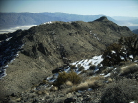
Corkscrew Peak, 5804':
A rather long, tough hike, off-trail, with an incredible view,
including Badwater and Mount Whitney. Ask for the
handout available in 0801. Park on the Daylight Pass road
somewhere between the Hells Gate parking area and the
"Corkscrew Peak" sign near the unmarked trail to Hole-in-the-Rock
Spring at about 2760'. (Further north is higher, but more work
(up/down) to get west into the main wash.) Follow the wash north to a
fork; continue left/straight into a slot canyon; look for an exit west
(I did not find or know about) before the major dryfalls (tough to
climb, scary to descend).
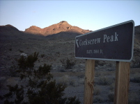
I went up-canyon a long way, ~2 mi to about 4000', NNE of the peak,
before finding a "good" up-and-out route on ridges to the north
subpeak (hard to avoid going over it, so don't fight it) and back
south a bit to the homestretch; took me 4:25 from 2760'. The handout
shows two other routes further west, the eastern one leaving the
canyon before the dryfalls, both reaching the saddle north of the
peak.
-
(!h)
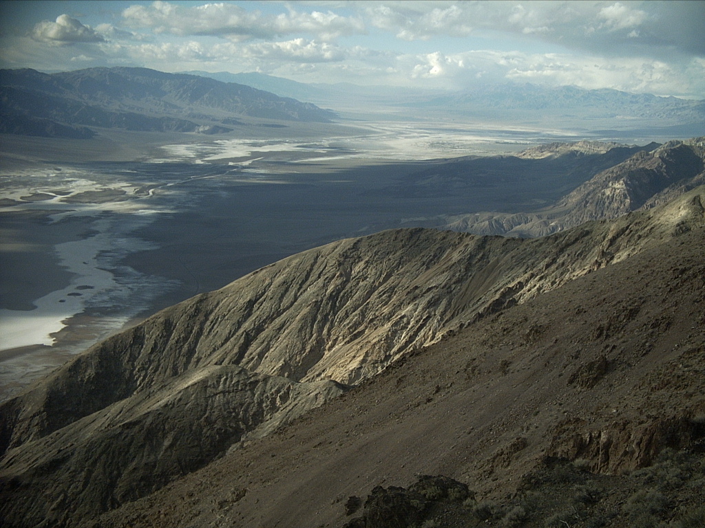
Death Valley Buttes:
Surprisingly spectacular views for a "little hill" poking out of the
slope up the Grapevine Mountains, west of Corkscrew
Peak, hard to even see unless you know where they are. Also
surprisingly rugged and airy at points to reach the higher west butte
-- not for the faint of heart.
From the Daylight Pass road from Stovepipe to
Beatty, Hells Gate parking (2262'), 22 mi northeast of
Furnace Creek, hike 1.8 mi OW southwest. (Actually started
~0.5 mi down road, closer to buttes, ~2160'.) East butte, 2720'+,
gain 560'; walk up on sometimes loose terrain. Saddle 2480'+, close
to east butte. West butte, 3017', gain 540' from saddle, total 1100'
if drop off saddle on return; last ~400' rocky (firm and smooth, and
pretty pink/purple); took me 1:10 total from car, 1:15 down via
saddle.
If you're adventurous, start hiking two hours before sunset; arrive on
top of the west butte in time to watch long shadows change. Start
down in time to clear the ridge scramble before sunset (unless you
have good moonlight and you're brave). Excellent views all the way
between both summits, along the ridge; bring binoculars! Get off the
ridge or east butte at sunset, and you're back to your car before
dark.
-
(nh)
Marble and Cottonwood Canyons:
Northwest of Stovepipe Wells; 4WD required. 13 mi to Marble,
18 mi to Cottonwood; 4WD after ~8 mi.
-
(nh)
Lemoigne Canyon:
Northwest of Stovepipe Wells; serious 4WD required. Road takes
off from pavement 6 mi west of Stovepipe, runs ~3 mi according to AAA
map, 4.4 miles to canyon mouth according to handout.
-
(!d)
Emigrant alluvial fan:
Cruise 2000'+ and 7 mi down the alluvial fan from Emigrant to
Stovepipe Wells at 60 MPH with the windows down and "Hooked on
Classics" cranked up... Near sunrise or sunset, the sand dunes far
below cast long shadows.
-
Tucki Mountain, 6726':
Hike from ~2660' on road, 9.5 mi from Stovepipe Wells to the
junction, unless you have 4WD to take the unnamed road up-canyon past
Telephone Canyon (rough at the first dry wash crossing, then
much better) to get within a 2-3 hour hike; or go up Mosaic
Canyon from ~1000', closer but much more vertical; see below about
Mosaic.
020409-10: Backpacked from Mosaic Canyon trailhead, 920'+,
10:04 to 5920'+ point at the head of the canyon, long and tough (a
major adventure), and overnighted there. (Started out carrying 1.5
gallons of water, and had just enough.) Went up Mosaic to the end of
the trail (see elsewhere), then turned right at a streambed fork onto
steep, complex ridges up to the west ridge, and across to the last
tough, loose climb up to the jagged 5920'+ point. Too spent to
continue 2.1 mi direct + 1200' (at least) to the true summit.
Next morning, descended west ridge, skirting many high points to the
east; serious map and GPS navigation needed lower to follow the
correct ridge back to the trailhead; 6:52 down.
020412: 4WD up mine road to junction in 0:38, then 1.9 mi further on
left fork across steep hill to end at 5450', then tough hike 1:52 to
broad Tucki Mountain summit, 1:31 back, some sidehilling or
reclimbing required; tiring terrain.
(h)
Tucki Mine Road:
2.5 mi to Telephone Canyon fork, 10 mi to the mine. Road
departs 1.7 mi uphill from Emigrant. See above.
-
(d)
Stovepipe Well:
An historic marker and rock cylinder out on the Sand Dunes dirt
road east of the dunes; the well is closer to the road north to
Scotty's Castle than to the other end, which is 2.2 mi east of
Stovepipe Wells Village. Val Nolan's Grave is nearby,
east of the well, north of the dirt road.
0204: South end of the road was gated closed.
-
(h)
Sand Dunes:
Sit on the highest dune; a short hike, half an hour (briskly) from the
nearest point on the road (but writeup says 2 mi). Note, from that
point you must go up and down a lot "across the grain" of the dunes to
get to the highest dune; oh well. Nice sunrise/sunset place.
-
Devils Cornfield
is worth walking around for a while, at least once, to see the
arrowweed (?) plants close up.
-
(d)
Stovepipe Wells Village:
On occasion some fearless coyotes can be watched here quite up close
and personal. It's possible to rent a swim in the pool for $4 (1003).
Camping is basic and not very private, but it's convenient; go to the
north end for darker and quieter.
SPW was founded in 1926 as the Valley's first tourist resort. A
developer hoped to build a bungalow resort near there, but his lumber
trucks became stuck in the sand at the present village site. It was
decided to unload the lumber and build there rather than continue, and
the Eichbaum toll road was created later (1926?).
-
(n)
Third Canyon west of Mosaic
is interesting, I'm told. It's hard to tell which canyon is which,
but there's one west of Mosaic with an equally large alluvial fan,
that I would call the second (not third) canyon to the west. I count
at least five canyons west of Mosaic. All of these are probably
better reached from the road than from the Mosaic Canyon TH -- more
uphill, but less cross-country.
1203: Hiked (slowly) 3:15 RT from road at about 320' (36.57883
-117.18077) up first big alluvial fan west of Mosaic to overlook deep
canyon from 1000', then dropped down 100' or more into it. A few
turns up it dead-ended at an impassible dryfall at least 100' tall,
1.33 mi OW from the car (36.56675 -117.16195). Hiked back out down
the canyon floor.
-
(!h)
Mosaic Canyon:
More crowded because it's more accessible and attractive than most
others. Interesting narrows in the first mile, gorgeous polished
marble and recemented fanglomerate. Drive ~2 mi up gravel road to TH;
hike 0.5 - ~2 mi, +~1000', past first ~30' dry fall via trail on right
side (facing upstream) to a second ~30' fall; climb above it (steep!)
up left wall onto an old miner trail.
9312: Went 1/3 of the way up Tucki Mountain summit from TH, ~2
mi, ~1800', ~1.5 hours.) Kevin Keirn got above the second, third, and
fourth falls, then 45 minutes more to a fifth fall: "Seems to me like
you could go up anything from there. Wide open, plenty of ridges to
get on on the east side of the canyon." He also reported that from
above he could descend on an easy miners' trail that met the canyon
floor well below the falls; hard to find going uphill though.
0204: Hiked here myself, see Tucki Mountain above.
-
Grotto Canyon:
Next east of Mosaic Canyon, with unmarked gravel road up from
pavement; ~1 mi hike into grotto and first dry fall from where the
road enters the wash and becomes 4WD (deep gravel); could 4WD nearly
to the end. Nice place for a picnic. Rough drive up ~1.5 mi from
Stovepipe Wells; avoid getting stuck in gravel where the road
drops into the wash, but probably 2WD OK with care for a while
further.
-
(n)
Explore further up; climb around falls: Non-trivial, whether you
ascend the steep gully just to the right of the falls (cliffy at
top) or the rubble-filled ravine further right -- gives access to
the other side of the steep gully, and keeps going well past the
grotto with no easy way I could find to get over to above it.
-
(h)
Little Bridge Canyon:
Next east of Grotto Canyon; 3 mi OW, an hour up the huge
alluvial fan just to get to the mouth, another hour on tedious gravel
to the first little arch on the right wall (canyon left), 1/2 mi in,
which is as far as I went (sigh, I thought that was it). Little arch:
UTM 492460mE, 4047080mN; 0.5 mi more to 20' arch: UTM 492900mE,
4046610mN.
-
(n)
Hike all the way to the bigger bridge, 20', that spans the canyon
(another 1/2 mi); spend full day, keep going; canyon narrows, I'm
told.
-
Mclean Spring:
Hike north off the end of the boardwalk ~2 mi total from the Salt
Creek trailhead. Find America's only below-sea-level waterfall (a
little thing, 1.5' high, -89' elevation), the hidden springs, and
remains of an old memorial sign to the original 49ers who camped here
while crossing the valley. Some wooden debris was still there -- how
old might it be? This area is known as Burned Wagons Point,
because the 49ers burned their wagons here to smoke their oxen into
jerky. It used to be off the main valley road, but it's now obscure.
The bronze sign for Burned Wagons Point is at Stovepipe Wells.
-
100319: Hiked to Burned Wagons Point (small sign still
there on a metal post) and Mclean Spring from the north,
where the pavement east of Stovepipe Wells crosses the low point;
scrubby, later marshy, trying to follow branches of Salt Creek;
sat on high point north of the Point for sunset; back fast along
old roadbed a bit east of the creek, emerging right by the car --
last part of the old road obliterated and invisible from the paved
road, just across from the south gate, now closed, to a dirt road
north to Stovepipe Well.
-
(!) From the Salt Creek boardwalk near the fork, go up the
east hills, less than 10 minutes but steep to the top, for a very
nice view. Follow the ridges south back to the parking lot.
-
(!h)
Salt Creek Nature Trail:
Turnoff is 13.5 mi north of Furnace Creek; ~1 mi in on gravel.
Walk 1/2 mi RT on boardwalk; admire the pupfish, except they hibernate
in the mud in winter and are not to be seen. (Visible 9603, 0204,
numerous, but < 1" long, and skittish.) This area shows up vividly
on infrared photos of the park because it is relatively lush. The
springs here feed Salt Creek, which runs many miles south to
drain into Badwater Basin. (It took me many visits to realize
this.)
-
Keep hiking north past the boardwalk; some amazing, pastel-colorful
scenery ~1.5 mi north (on the way to Mclean Spring), with
badlands, marshes, and ponds.
-
(d)
Mustard Canyon:
Short dirt road drive, just north of Furnace Creek, worth doing
once.
-
(d)
Harmony Borax Mine Ruins:
Just north of Furnace Creek. Worthwhile if you catch a
ranger-guided tour.
-
(n)
Cottonball Basin: (36.518236 -116.944342 per Google):
Hike 2 mi OW west (later handout said 2.5 mi OW northwest; later
handout deleted this hike) cross-country from Harmony Borax
mine ruins (closer from north on road?); see piles, windrows, and
"haystacks" from 1883-88. Might be wet/muddy after rains. Haystacks
apparently hard to find; trails are gone.
-
(!d)
Furnace Creek:
Tour Visitor Center, study master binder of information handouts,
request the ones you need; admire the huge 3D map; study master binder
of topo maps. Buy Death Valley dates, grown at Furnace creek (9603:
$4.50-$5/lb, "the lowest date in America"). Visit nearby museum. Buy
souvenirs at store. Eat cafeteria food.
Springs:
Look for the source of one of the creeks that runs into the Furnace
Creek area. Admire the 10,000-year-old water seeping out of the
ground. In particular I heard that Furnace Creek gets about half of
its water from each of these:
-
Texas Spring:
Hike ~1.5 mi north from the north end of the campground, +400'.
Follow the trail -- it's further than you think, and not obvious
even with a map. You can hear the water roaring down the pipe.
Also walk around the white dome (water storage and treatment)
downhill from this spring, near the Inn.
-
Travertine Springs:
Also explore around the lush vegetation north of the road a few
miles up the Furnace Creek Wash road, northeast of the Inn.
Gazebo (36.453295 -116.85126) above Furnace Creek Inn:
A short, steep walk on social trails from the upper end of Texas
Spring campground or the Furnace Creek Inn to the decaying
skeleton of a gazebo on a prominent hilltop with nice views.
-
(n)
Mesquite Thickets:
From 1.7 mi south of Furnace Creek, hike 1 mi OW west to see
evidence of ground squirrels, kangaroo rats, and coyotes, said an old
handout.
-
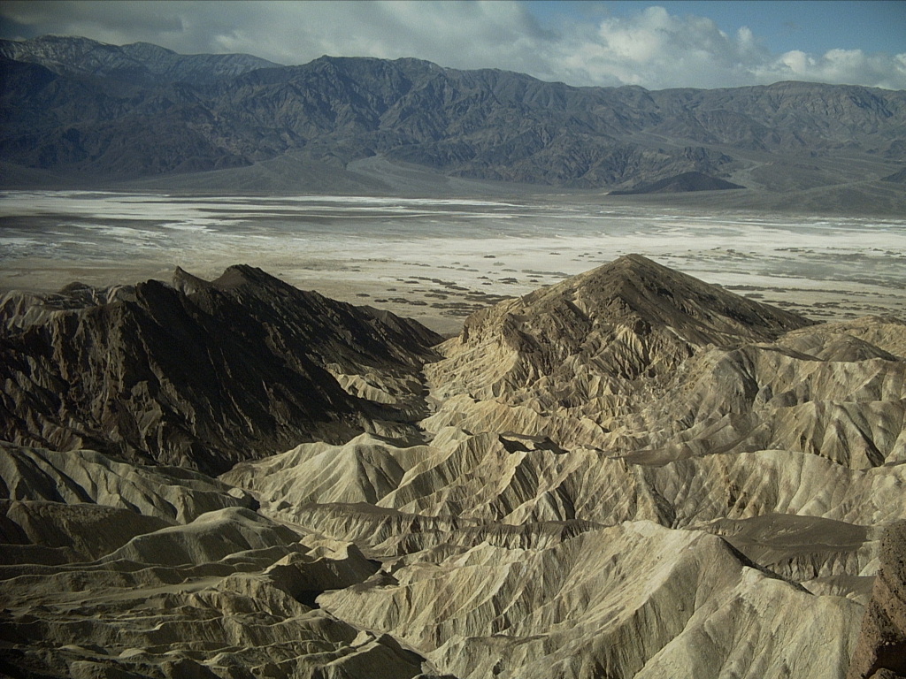
(!h)
Badlands:
Hike into the badlands below Zabriskie Point, 710'. Make a
loop up Golden Canyon, -160', to the Point and back down the
next wash south (Gower Gulch); handout said 5.5 mi RT; later
writeup says 4 mi; allow at least three hours. It's a mind-boggling
place.

(Gower was connected to Furnace Creek Wash by people, sometime
around 1940, to protect Furnace Creek Inn from floods. It has
a floor of dark stones from Furnace Creek Wash, although some of its
tributaries also cut into darker pebbles from upper layers.)
-
Hike 1 mi up Golden Canyon, then 1/2 mi more past last the
numbered marker (follow signs) to Red Cathedral, which are
washes ending at high red cliffs, including narrow "chimneys".
-
(!)
Find the torturous route from the east up the north ridge of
Manly Beacon (36.423608 -116.826131). ("You're in a maze of
twisty little passages, all different.") Also visit the huge, neat
alcoves further up the same gully northeast of the Beacon. Both ~1
hour OW from Zabriskie; non-trivial.
-
(!)
Hike 1/2 hour northwest from Zabriskie on the trail above the red
cliffs (Red Cathedral Ridge); somewhat steep and loose, but
an incredible panorama.
-
Make a tough round trip up Golden Canyon to Zabriskie Point, then on
a reasonable trail along or behind the ridgetops to above the Red
Cathedral. The hard part is getting back to your car from
there, if you don't start from Zabriskie Point, or return in that
direction. I found no way through the cliffs from Golden Canyon on
the way up, so I continued to Zabriskie and made a counter-clockwise
loop instead. From west of Red Cathedral, I descended to the north
of Golden Canyon. Very steep here, with big dryfalls... I found a
doable route through cliffs into a wash ending on the Badwater road
0.62 mi north of the Golden Canyon parking lot; expect ~5 hours
round-trip.
-
(n)
Hike into chocolate badlands up gullies northwest from Gower
Gulch below Zabriskie Point.
-
(h)
Desolation Canyon:
Enjoy the slot canyons in mudstone. (Left fork of the dirt road in
from the highway. 0204: No marker sign at highway or on the map;
it's the next dirt road north of the Artist Drive exit, on the
same (east) side, or 3.7 mi south of CA 190.) You can hike the main
channel all the way out to overlook Artist Drive, ~2 mi OW;
handout said to go right at all forks (I guess I did).
-
(d)
Mushroom Rock:
A ventifact (sandblasted) in basalt, undercut just as high as sand
gets airborne, at the terminus of an old lava flow, at a pullout just
east of the road, just north of the Artist Drive exit. No
longer signed or on the map because people have knocked down part of
it. The ridge east of here is informally known as "Ventifact
Ridge".
-
(!)
Mars Hill:
Walk up and around the eroded basalt lava flow terminus across from
the exit from Artist Drive, and observe how much it looks like
the pictures of Mars returned in 1976, especially through orange
sunglasses. (A Russian Mars rover was tested there in 9205. I made a
formal proposal to the USGS Board on Geographic Names to get it named
Mars Hill; it was approved 950613. The hill was on the 1995 AAA map,
but in the wrong place; corrected on later maps; then absent again
from the 2000-2004 edition, sigh.)
-
(n)
Circumnavigate, look for petroruins (rock rings, foot trail).
-
(!d)
Artist Drive and Artists Palette: Hike around the
Palette area; wild combinations of rainbow colors, though all pastels,
and some surprises, like natural tunnels. Red, pink, yellow, orange,
and brown colors result mainly from combinations of hematite, a red
iron oxide, and limonite, a yellow iron oxide. The violets and greens
are volcanic in origin. Nice sunrise/sunset area. Also numerous side
canyons along the road (right side) before the Palette:
-
First major dip (with sign) is a short, narrow slot, ~10 min
walk to impassable dryfall in crumbly mudstone. (Mouth ~36.34791
-116.79192.)
-
Second major dip (with sign) is a wider, bouldery canyon,
some fun scrambling; went up ~15 min and it kept going. Reputed to
be some nice narrows higher above. Gains quickly from 860' at road
to 1600', then shallows east to bowl around 2200'. (Mouth ~36.35496
-116.79449.)
-
(!)
Third major canyon, drains past Palette, look back as road
curves left just past a smooth hillside with many parallel drainage
lines, just before Palette turnoff; ~15 min OW up to short but
sweet, deep, sinuous slot canyon; two small dry falls to climb to a
~50' circular, grotto-like end surrounded by cliffs; possible to go
higher with scrambling? (Sigh, it seems I never have enough
time.) Apparently it is, a friend did it. (Mouth ~36.36132,
-116.79591.)
-
(!)
First and second dip canyons merge into a very nice downhill walk
back to the main highway. In 2005 when Artist Drive was
closed due to flood damage, hiked up the road to the Palette, ~4
miles, then uphill to this gully and down the gully back to the car,
~3 miles, in a total of 6:05 including side-trips up the first and
second dip canyons. Exit the gully at the mouth to the left for a
smooth walk downhill right back to the Artist Drive entrance.
-
(d)
West Side Road:
-
Tule Spring parking is a short distance off the road, then
you can walk a long ways east toward the salt pan on a trail, past
various trees. The actual spring was hidden in a copse of thick
bushes.
-
(!)
Nice sunset spot where the road crosses Salt Creek on the
north end, ~2 mi from pavement.
-
(!d)
Devils Golf Course:
"Hike" among the salt sculptures for an hour -- carefully! They're
razor sharp. Look for little salt chimneys, arches, etc. Get far
enough from the parking lot to see untrammeled salt sculptures (and
try not to trample them). This area was left when Lake Manly dried up
2000 years ago.
-
Search for star-shape just southwest of the Golf Course, easily
visible from Dantes View, but tough to find on the ground
even with 35 minutes of hopping around (can't see the forest for the
trees); apparently from WWII salt-gathering operations. Bring a
periscope? :-)
9702: Found it; not very impressive, though.
-
(n)
Search for deep pool reputed to exist some years about 100 yards
south of the parking lot; walk east first to easier terrain.
1203: Hunted around out to 0.21 mi from the parking lot and found
nothing.
-
(!h)
Natural Bridge Canyon:
Drive 1.5 miles up gravel road from Badwater Road, 13.2 miles south of
190. Make the short but tiring walk on gravel 0.3 mi up to Natural
Bridge, a huge conglomerate arch.
-
Can climb up to the base of the span on the left side (river right),
into the old oxbow. Use caution.
-
Continue up-gully ~1/2 mi further, at least as far as from TH to
bridge (writeup says 1 mi total), up through two smaller dry falls,
to an impassable dry fall.
-
(n)
Climb further up left fork (canyon right) near impassable dry fall.
Might exit to high saddle?
-
Explore next canyon south (to right) from TH; ~10 min up and into
narrows ending at dry fall, with a nice view out to
Telescope Peak.
-
(!)
Salt Flats:
Standing water+mud worst in Jan-Feb. (However, it was almost bone dry
every time I visited except late 9301 after unusual rains, and
standing lakes in some later years.) Hike out onto the salt flats
from Badwater (a pool fed by a saline spring) and lose yourself
for a few hours in the vast, barren silence (assuming no wind
blowing). In the summer of 1913, Badwater's record high was 136
degrees F. ~20 min OW suffices to get you well out into the salt pan.
Nice sunrise/sunset place. Awesome view back toward Badwater and
Dantes View... Imagine hiking from the former to the latter!
(I did it, 9702, < 8 hours, one way only; steep, loose, long,
awesome; see below.)
-
Badwater (-279') to Dantes View (5704' at the marker):
Climb, ~6800' total gain, rough terrain, some route-finding on lower
ridges. A ranger did it in both directions, but on the long,
continuous ridge much further south, ending ~2 mi south of Badwater.
(Years later I heard he actually started well north of Badwater and
climbed to intersect the route below.) I went south from Badwater up
the alluvial fan (10 min), then up the ridge above Badwater -- narrow;
spectacular views; ~1 hour to 785' high point; initially steep and
loose, and some scrambling enroute. Dropped southeast ~40' to next
ridge; then steep, loose scramble up complex, rocky hillside above
this. Hoped to cross gully to reach 3815' high point, but too deeply
incised, with dry falls; and saw nasty cliffs between that high point
and Dante anyway. Continued northeast up loooong ridge to well
north/northeast of Dante and back around on the ridgeline, approaching
the summit marker from the east; just under 8 hours to the marker.
Definitely the "right" way to do this hike. Arrange a ride or a bike,
or hitch down (like I did); avoid a nasty descent.
Consider alternate route to/from Dantes View (southeast ridge): Start
on Badwater Road at 36.199958 -116.768661; very steep at the
beginning.
-
Salt Flats circles:
Walk from road south of Badwater out to one of several brine pools
(usually dry), large circular features 700-1000' across (two visible
from Dantes View, all 3-4 visible on Google Maps).
1203: Walked from road 0.91 mi OW to center of biggest circle
(36.187553 -116.787148).
-
(ndh)
Trail Canyon:
12 mi from West Side Road; 8.3 mi on AAA map to fork, spring,
and mining area. Legal to camp, and a great view, 2.0+ mi up from the
West Side Road, but it's rough, 8 MPH, barely 2WD. Aura Carmi wrote:
"If you have a 4 wheel drive truck, go up and take the left fork. At
the end is a great canyon for boulder hopping."
-
(ndh)
Hanapauh Canyon:
9 mi from West Side Road; 5 mi to canyon mouth and start of
4WD.
-
Coffin Canyon (mouth 36.15258 -116.766393):
East of main road between Badwater and Mormon Point,
next mouth north of Copper Canyon. A non-descript mouth for a
canyon that drains a huge area all the way up to Coffin Peak to
the north. A short walk (under 1/2 mile) up the alluvial fan from the
road enters the canyon, and a 50'+ tall dryfall blocks passage soon
after that. Round-trip can be under an hour.
-
(n)
Copper Canyon (mouth 36.128459 -116.753347):
Explore it; east of main road between Badwater and Mormon
Point. Restricted access due to 6 MYO mammoth tracks ~3 mi in;
ranger-led group hikes a few times/year; call ahead to join.
-
(nh)
Johnson Canyon:
10 mi from West Side Road, definite 4WD; hike 1.5 mi more to
Hungry Bill's Ranch ruins. Ranger said it's pretty -- a
running stream, rock walls.
-
(n)
Sheep Canyon:
It was recommended to me.
-
(n)
Willow Creek Canyon:
Explore it; near Mormon Point. The Gold Valley road
ends up this canyon.
-
"Sidewinder Canyon":
Next south of Willow Creek, best slot canyons, but ugly
conglomerate (Mosaic and Desolation are nicer).
-
(ndh)
Butte Valley via Warm Spring Canyon:
Drive west from West Side Road; 4WD (or at least high
clearance) beyond talc mines (~11.2 mi OW); eventually connects to
Ballarat in Panamint Valley. Striped Butte,
4773', is in Butte Valley; reputedly a very pretty place.
100318: Got past the upper (White Point) talc mine at ~2330' in a
Subaru wagon before it got too seriously rough to continue. The "talc
mine" was a huge slope of white tailings, and the White Point mine is
an actual underground adit with a barred entrance.
-
Cinder Hill (aka Split Cone):
Start ~1.9 mi up from south end of West Side Road; hike west a
short distance to a volcano cut in two by a fault line. (Saw an
interesting aerial photo at the visitor center.) Took just 15 min to
visit both summits. ORV tracks here, sigh. Old (?) clearing and
rock ring on higher hill.
-
Shore Line Butte, 663':
Start from West Side Road or Ashford Mill Ruins (built
and abandoned in 1915); hike ~1 mi or more to the terraces on the
butte (north end). Surprisingly hard to spot the terraces while
hiking across them; reputedly a dozen total, but I was only sure of 5
of them. Nice sunset spot if you come down the big wash on the east
side; helpful to have a GPS to walk directly back to your car after
dark! I did a fast round-trip in 2:05 one evening, including down the
main wash from Ashford Mill to the north foot of the Butte before
ascending.
100318: Hiked second time, this time directly up and down the wash,
2:50 round trip with 35 min on top. Numerous cairns around the main
summit, including remnants supporting a missing survey tripod.
-
(d)
Saratoga Spring:
Largest pool in DVNP, far south end; 4WD (sand, gravel) from the Park,
easiest by approach from CA 127 west, north at junction, west again.
~1 mi loop hike around the pond? Short walk up hill from parking lot
at end of road to overlook. Possible to visit in ~1 hour round trip
from pavement if you don't stay too long at the spring.

-
(nh)
Ibex Dunes are nearby.
-
(nh)
Eureka Dunes:
Doug Landauer wrote: "They're northeast of Saline Valley.
There's a rough 4WD road that connects Saline Valley and the Eureka
Dunes. [0204: Heard to be a very tough road.] But the more
normal way to get there is via the good dirt road called 'Death Valley
Road' that goes northwest out of the northern end of Death Valley, and
then bends west to get to Big Pine. The Dunes are very roughly
halfway between Scotty's Castle and Big Pine. They're
like the dunes in Death Valley itself, except: Taller, more
extensive, and much more remote (most tourists seem to avoid dirt
roads, thank goodness) therefore fewer people."
-
(dh)
Saline Valley:
Hot springs (awesome; clothing optional), petroglyphs, sand dunes,
weird cooperative desert-camping community. (Springs shown on park
map handout, but not labeled.) Jets buzz by from China Lake.
Al Knoll wrote: "The north road out of Saline is an interesting one
and you should give it a try when you have the 3-4 hours to spare on
your way up to the old trees in Schulman Grove."
0204: Saline Valley Road was very rough and slow from Lippincott
Junction to warm springs turn off; better south of there over
South Pass, but still 37 mi direct from the springs to
Stovepipe Wells, 98 mi odometer, took 3:05 (!) with minimal
stops.
-
(n)
Cerro Gordo:
Talc mine site, in the Inyos on Saline Valley's southwest rim.
Tramways, mine/ghost town. Drove by 0204, but didn't take time to
explore.
-
(n)
Tin Mountain, 8900' (36.886772 -117.456129):
Start ~4800', up canyon SSW of peak then around NNE, ~3 mi OW. Hike
east several miles from the Racetrack Road about halfway to
Teakettle Junction. (I just saw this driving past it, and see
it on the map; no more info about it.) Looks like about 4800' to
start, so a lot of vertical, up a canyon SSW of the peak then around
NNE to the summit, about 3 miles each way.
-
Corridor Canyon from Ubehebe Lead Mine, ~3840':
The low end of Corridor is ~2880'; that's right, you hike
downhill to it. (Corridor Canyon unnamed on map, maybe a
familiar name?) From Racetrack Road between Teakettle
Junction and The Grandstand, watch for an unmarked right
turn as the main road turns left toward the playa. Drive up a small
rise, actually a saddle between Racetrack and Saline Valleys,
then down, total 0.7 mi, marginal 2WD with care (rougher in 0204), to
the wreckage of the Ubehebe Lead Mine and end of the road.
(Too bad 50 years turns trash into antiquities...)
Hike down the unnamed canyon past mine ruins on surprisingly firm
gravel (more consolidated than Natural Bridge Canyon or Fall
Canyon); brown limestone, not real colorful or pretty. Watch each
fork for return route -- basically "bear right all the way home" --
never mind cairns. Go west, northwest, west, southwest, around a
half-circle. Hit small blue limestone falls, then pop out onto a huge
wash. Petroglyphs (mainly bighorn) and old graffiti here, river left,
just inside side canyon. (Didn't see them until on the way back.)
Continue down huge wash, it narrows, winds around, then gets into more
blue limestone/marble. Gorgeous ~10' dryfall, slight scramble
straight down it, then veined falls/slots, not real big but very
pretty. Pops out at top of Corridor as another side canyon; a 2/3
mile section (1355 paces) of nearly perfectly straight ravine, with
~20' walls, smooth, tilted back a bit, higher and less-steep terrain
above that. Not really narrow like a slot canyon, but impressively
long and straight, with a flat floor. You can't see it all -- it jogs
just a bit -- unless you climb up a little at either end. Walk the
length of it! Nearly 15 minutes to the far end, and an abrupt right
turn. Very remote feeling here!
(Resist any temptation to continue down-canyon and disappear into the
mists of time in Saline Valley.) About 1000' total gain, 3-4
miles one way, 1:30 to end of Corridor, 1:55 back with some stops.
-
(h)
Racetrack Playa:
3708', 2x3 mi in size, ~26 mi drive, rough road up to first pass, then
better in spots; few big ruts, holes, or rocks, but world-class
washboards; took 1:45 to The Grandstand in a Cavalier, average
10-15 MPH (!); better on a later trip in 0204. Very remote, be sure
vehicle is in good shape, bring lots of supplies.
-
Hike to moving rocks, best at south/southeast end near cliff that's
their source, at least 1/2 mi hike, but about an hour suffices.
Tracks are bizarre, ranging from clear to faded; all directions;
looping around randomly; some with rocks at their ends, others not.
I paced one track at about 880' long. Thought all rocks were near
the source, but binocs showed them scattered all over the playa,
just thinner away from the source, as if they decay into rubble, or
they pick up speed and get across. See what you think.
-
(h)
The Grandstand, 3781':
Hike to, up, and around it; < 1 hour. Source of rocks is 2.13
miles south from center of Grandstand.
-
Walk from the Grandstand to the source (0:50 in 0204), or follow
some rocks to their destinations on the northeast side of the playa.
-
(h)
Ubehebe Peak, 5678':
High point of the ridge between Racetrack and Saline
Valleys, with spectacular views. Climb from The Grandstand
pullout, 3708', ~2.5 mi OW, ~2600' total gain (handout said 1800' but
that's wrong); no sign at trailhead, but excellent trail to west side
of 5519' north summit, then a big drop to saddle, 5200'+, and rise to
the summit with some scrambling and route-finding challenges. Made it
in 1:55 to summit (briskly) and 1:20 down. Worth a ~3 min stroll to
the south summit too.
-
(ndh)
Hunter Mountain / Hidden Valley:
Various 4WD from Teakettle Junction, 22 mi from pavement.
-
(d)
Lippincott Lead Mine and Road:
A couple miles south of the Racetrack, some interesting lead
mines a short distance on a left fork. Down the right fork is a
warning sign and the Lippincott Road, serious 4WD but passable
0204, ~7 mi, ~1.5 hours with stops, to the Saline Valley road,
nice views. A few bottomings and a couple back-and-fills in a Suzuki
SUV.
-
(nh)
Panamint Dunes:
"Wonderful, but a good walk." Can 4WD closer on Big Four Mine
road?
-
(!d)
Panamint Valley:
Continue west from the road up the Panamint Range over Towne
Pass -- a spectacular drive down. Duck when the military jets
scream through.
-
Dry Lake in Panamint Valley: Sigh, it's part of the Park
now, you can't drive on it any more, not even on the south side. I
recall the old Caltech geology department field trip bus kicking up
some dust there in 1974 during my first visit...
-
(d)
Panamint Springs:
Little oasis, supposedly a nice sunrise/sunset spot. Al Knoll wrote:
"Jerry is a character, the showers after desert dust are delicious,
and the inexpensive shaded camping is nice if you have a group or
not."
-
Darwin Falls:
Southwest of Panamint Springs in the Argus Range. Look
for a marked turnoff ~1 mi west of town, south 2.4 mi (not bad), right
0.3 mi (nearly 4WD) to TH at fence. Then walk and bushwhack braided
trails ~1 mi OW, ~30 min, through gorgeous green serpentine narrows,
to a Garden of Eden at the small falls. Nice lunch spot? The water
emerges from underground springs and vanishes again downstream.
-
(d)
Rainbow Canyon:
West of Panamint Springs, along road, quite spectacular.
-
(ndh)
Skidoo:
Ghost town, 9 mi dirt road (is a deterrent); nothing left but
an interpretive sign, I heard.
-
(ndh)
Harrisburg:
Ghost town ~2 mi down the Aguereberry Point road, on the right.
-
(!d)
Aguereberry Point:
Excellent view east from 6433', except "Tetracoccus Ridge",
informally named for a bush -- "rare and elusive Tetracoccus
ilicifolius, a rare shrub in the Euphorbiaceae family" -- blocks some
of the view. Very remote spot; eroded marble outcrops. Walk a short
way from parking lot at end of road, on the left side of the marble
outcrop, to look down over the valley. Road in is ~6.3 mi OW,
unpaved; usually in pretty good shape (0801: a few rough spots).
Nice sunrise/sunset point. Observe that after dark you can pick up
KOA 850 from Denver, 700 miles away.
-
Tetracoccus Ridge:
Scramble east down and back up from Aguereberry Point, ~1 mi
OW, ~500'; southern high point looks unreachable due to cliffs. Steep
descent to saddle, then a tough, loose ~400 gain to the next summit.
Nice view, but the rest of the ridge still blocks some of the valley.
Several hundred feet down to the next saddle, then you climb to a
rocky gendarme (pinnacle) with no easy way around it... Bummer. Took
30 min back from the first saddle to the parking lot.
-
(n)
Return again some day, and spend a lot more time finally reaching
the far end of the far ridge. But still probably can't get up the
rocky bump at the south end.
-
(h)
Wildrose Peak, 9064' (36.275602 -117.078731):
Easier hike than Telescope Peak, 4.2 mi OW from north end of
Charcoal Kilns, 2200' gain. Good alternative when open while
Telescope is closed by snow. Lower, tree-covered trail, but has a
broad rocky top and a nice view, including Sierras. Spectacular views
start ~2 mi up trail; steep grade for last mile.
-
(d)
Mahogany Flat (8133') / Charcoal Kilns:
Collect pinion nuts (yes, it is/was legal). (931210: They were a bit
past prime; gathered 1.5 lbs in ~40 minutes; bring a sifter?) The ten
kilns are weird to look at, and they have strange echoes inside. The
road up to the flat is very steep, but was 2WD-able if free of snow.
-
(h)
Telescope Peak, 11049':
Hike (non-technical except in winter), ~7 mi OW, 3000', from
Mahogany Flat. Bristlecone pines starting at 10000'; highest
point for 70 mi, but the road is likely closed a ways further down by
snow in winter -- so visit Wildrose Peak instead. Best times
for Telescope: Sept-Oct or April-May; usually snow-free by June. Bad
road, add ~1.8 mi one way hiking if starting at Charcoal Kilns
(road OK up to there).
9312: Last ~2 mi to kilns unpaved and rough; last stretch to flats
not much worse, just steeper.
-
(n)
Spend night on summit.
-
(n)
Hike from Shortys Well, -253', up Hanaupah Canyon,
exit right onto long but straightforward ridge to summit, gain
11300', end up 7 mi from nearest TH. Someday when I'm younger...
-
(nh)
Panamint City:
Ghost town 11 mi northeast of Ballarat; no longer vehicle
accessible.
-
(ndh)
Ballarat:
Ghost town off the Panamint Valley road; 400 inhabitants in
1898.
-
Trona Pinnacles:
More than 500 pinnacles composed of calcium carbonate (tufa) deposits
up to 100' high, rising out of a dry lake bed. Thought to be caused
by a combination of hot saline springs and drying of the lake. On the
south end of Searles Dry Lake east of Ridgecrest.
The following table summarizes the author's personal history of Death
Valley trips over the years, as reconstructed in 2008 from various
sources.
| Num |
Dates |
Nts |
With |
Highlights |
| 1 |
1974.0421-22 |
1 |
Caltech geology class bus trip |
Alkali flats; Badwater; Devils Cornfield; Stovepipe Wells CG; Mosaic
Canyon; Emigrant; Panamint Valley
|
| 2 |
1977.0614-16 |
2 |
parents, post-graduation |
Stovepipe Wells motel 1-2 nights; sunrise hike from SPW
|
| 3 |
1981.0519-20 |
1 |
Spring Carlton |
Badwater; Devil's Golf Course; Furnace Creek; Zabriskie Point; Dantes
View; Mustard Canyon; Stovepipe Wells; Mosaic Canyon; Emigrant; Towne
Pass; Panamint Valley
|
| 4 |
1983.1214-16 |
2 |
Spring Carlton, Megan Silverstein |
Panamint Valley; Wildrose; Aguereberry Point and hill to west;
Stovepipe Wells (motel 2 nights); Wildrose Peak; Emigrant; Furnace
Creek; Badwater; Artist Drive; Grapevine; Ubehebe Crater and Little
Hebe
|
| 5 |
1985.1028-30 |
2 |
Megan and Sandra Silverstein |
Badwater; Artist Drive; Mahogany Flat, Telescope Peak, 11049'
(solo); Badwater, Mustard Canyon
|
| 6 |
1987.0817 |
0 |
(solo) |
Passed through one long day: Stovepipe Well; Furnace Creek (110
degrees); Badwater; Desolation Canyon; Golden Canyon; Travertine
Spring
|
| 7 |
1989.1231-1990.0102 |
2 |
Sherry Perkins |
Mesquite Springs; Ubehebe Crater bottom; Aguereberry Point; Mosaic
Canyon; Stovepipe Wells; Furnace Creek CG; Zabriskie Point; Twenty
Mule Team Canyon; Dantes View; rainy Artists Palette; Devils Golf
Course; Natural Bridge; out to nearer -282' point; Badwater
|
| 8 |
1993.0121-26 |
5 |
(solo) |
(Wrote short trip report:) West Side Road, Amargosa flowing;
Badwater (flooded); Mars Hill; backpack Funeral Peak, 6384',
overnight; Golden Canyon, Zabriskie Point, Gower Gulch; Furnace
Creek; Little Bridge Canyon; Aguereberry Point backpack overnight;
Upper and Emigrant Springs; Grotto Canyon; Stovepipe Well; salt
marshes north of FC; Zabriskie Point to Manly Beacon north ridge;
Texas Springs; Desolation Canyon to Artist Drive overlook; Devils
Golf Course hike; wade out from south of Badwater; "Sidewinder" slot
canyons
|
| 9 |
1993.1206-12 |
6 |
Ivy Springer |
Badwater; Texas Spring CG; Golden Canyon, Red Cathedral, Manly
Beacon north ridge, Zabriskie Point, Gower Gulch; Mars Hill; highest
sand dune; Harmony Borax Works tour; Mustard Canyon; Twenty Mule
Team Canyon; Dantes View and benchmark; Devils Golf Course; Artist
Drive; Natural Bridge; West Side Road ~10 miles down first time;
Salt Creek, Mclean Spring, Burned Wagons Point; Aguereberry Point;
Mahogany Flat, pinion nuts; Panamint Valley; Devils Cornfield;
Mosaic Canyon, first time beyond 2 mile dryfall; Texas Spring;
Devils Hole
|
| 10 |
1996.0309-16 |
7 |
Megan Silverstein (spring break) |
(Wrote trip report:) Rhyolite (first time), Titus Canyon drive;
Texas Springs; Mushroom Rock, Mars Hill; Badwater; Natural Bridge;
Devils Golf Course (twice); Artist Drive (twice) and Palette; West
Side Road, Salt Creek crossing; Salt Creek Nature Trail; Grotto
Canyon; Panamint Valley; Darwin Falls; Wildrose CG; Charcoal kilns;
Aguereberry Point; Mosaic Canyon; Zabriskie Point, second time up
Manly Beacon north ridge; Twenty Mule Team Canyon; Dantes View;
Texas Springs hike; Comet Hyakutake; Amargosa River; Ashford Mill
|
| 11 |
1997.0215-0220 |
5 |
(solo) |
(Wrote trip report:) Hiking frenzy, 13,300' gain, ~40.5 miles, over
31 hours: Trail Canyon; Comet Hale-Bopp; Badwater, -272', to Dantes
View, 5704'; first time to Racetrack Playa, Grandstand; Ubehebe
Peak, 5678'; Ubehebe Mine, Corridor Canyon; Death Valley Buttes,
3017'; Fall Canyon; Devils Golf Course, locate "asterism" ~10 min
SSW; first hike to -282' low point; Cinder Hill / Split Cone
|
| 12 |
2002.0407-13 |
6 |
Jenny Pruett, Greg Carr |
(Wrote trip report:) Had Suzuki XL7 4WD: Artist Drive, Mars Hill;
second hike to -282' low point; Salt Creek sunset; Stovepipe Wells;
Mosaic Canyon backpack; Aguereberry Point sunset; 4WD second time to
Racetrack Playa; hiked Grandstand south; Lippincott road; Saline
Valley warm springs; 4WD and hike Tucki Mountain, 6726'; Zabriskie
Point sunrise
|
| 13 |
2004.1026 |
0 |
Cathie Grow |
One long day from Las Vegas; very windy: Ashford Mill; Badwater
walk; Natural Bridge; Devils Golf Course; Mars Hill, Mushroom Rock;
Borax Museum; Furnace Creek visitor center; Harmony Borax Works;
Mustard Canyon; Mosaic Canyon sunset; Stovepipe Wells; Rhyolite
(dark and rainy)
|
| 14 |
2005.0312-14 |
2 |
Cathie Grow |
Rhyolite; wildflowers; Furnace Creek visitor center; packed Sunset
CG; hike Artists Palette (road closed); float on "Lake Manly"
(inflatable raft); Texas Springs; Salt Creek nature trail and up
hill east; Stovepipe Wells; Panamint Valley; Grotto Canyon; Beatty
cutoff beach bar; West Side Road to Salt Creek crossing
|
| 15 |
2008.0129-0203 |
5 |
(solo) |
Saratoga Spring; Shore Line Butte at sunset; Corkscrew Peak;
Tetracoccus Ridge; 8th DVNH conference (2 days); camp up Trail
Canyon; Tule Spring; Golden Canyon / Red Cathedral Ridge loop;
Dantes View; Greenwater Valley drive
|
| 16 |
2010.0317-0321 |
4 |
(solo) |
Camp south end of Greenwater Valley; hike Shore Line Butte again;
drive West Side Road including 11.2 mi up Warm Springs Canyon; Texas
Springs; hike low point on salt flats and (barely) float kayak in 6"
deep brine nearer to Badwater; hike Mclean Spring and Burned Wagons
Point from the north for sunset; Stovepipe Wells; drive Titus Canyon
second time, hike Thimble Peak 6381'; camp north end of Greenwater
Valley; Dantes View sunrise and hike both ways.
|
| 17 |
2012.0225-0303 |
7 |
(solo) |
Camp north end of Greenwater Valley; hike Mount Perry from Dantes
View; camp at Texas Springs and wake up with bronchitis,
which mostly ruined the rest of the week; hike Furnace Creek Inn
gazebo (decaying) and inside, loop; short ranger walk in "Kit Fox
Hills"; short ranger walk out from Badwater; explore ~880' diameter
"sinkhole" 0.91 mi from Badwater Road a few miles south of the main
area; explore borax pit mine near Ryan (center of pit = 36.340785
-116.706973, ~1/2 mi SW of DV road at ~2240'); hike to Coffin Peak
from Dantes View toilet parking; hike from ~320' on road to ~1000'
at dry fall 1.34 mi from car in first major canyon (next big
alluvial fan) west of Mosaic; explore Devils Golf Course 0.21 mi out
looking for but not finding alleged brine pools; stroll up Coffin
Canyon to huge dryfall just inside mouth; camp south end of GWV.
|